

How to Get Around During Paris Pride
Parade Route
A new course has been arranged for the march this year. The Inter-LGBT said this on the subject:“After two weeks of negotiations with the Paris Prefecture of Police and the Ministry of the Interior, a new course was set for the proper conduct of the March of LGBT Pride of Paris.”
(Original quote in French can be found here.)
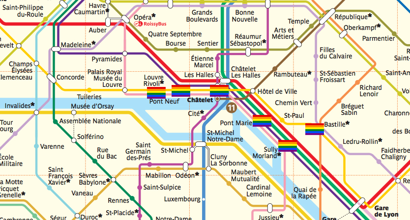
The course will start at the Louvre with a departure time of 14:30. The March will then follow the waterfront East and come to an end at the Bastille.
The Paris Metro
The Pride March takes place right in the centre of the French capital so getting there should be easy. The March route starts at the Louvre and passes by Pont Neuf, Pont Marie, Sully Morland and finishes at Bastille. Châtelet station isn’t directly on the route but is very close. In fact most of the neighbouring metro stations are only a 10-15 minute walk away. So if you’re looking to avoid the crowds, heading to metro stations like Pyramides, Cité or Les Halles will be a good option. If you need help planning a route, don’t forget you can download Paris Metro for free!
How to Get Around During Madrid Pride
Parade Route
The Madrid Pride parade is one of the biggest Pride events in the world. So much so, that it was officially moved so that it wouldn’t overshadow smaller regional events. On Saturday July 2 it will set off from Atocha then continue North along the Paseo del Prado. The parade then finishes at Plaza de Colón.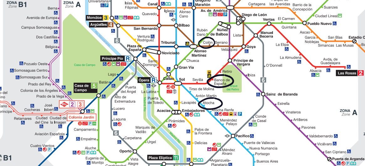
The Madrid Metro
The Metro stations Atocha, Banco de España and Colòn are all on the parade route. Of course this means they’re all going to be very busy so you might want to look at the surrounding metro stations if you want to travel in. The following stations are all within walking distance of the parade route. Palos de Frontera, Lavapiés, Antón Martín, Sevilla, Chueca, Retiro and Serrano. If you need help planning your journey on the metro, make sure to download Madrid Metro for free. This weekend two great cities, London and New York, will be celebrating Pride. Both cities will host a parade and there will be big celebrations bringing in huge crowds.
The London Pride Parade is the biggest of its kind in the UK and aims to celebrate diversity in the LGBT+ community. It’s also part of the larger Pride festival, a series of events that runs from June 7 to July 2.
The NYC Pride Parade (technically a March) started as an annual civil rights demonstration. Over the years its purpose has broadened and is now a celebration of life and the LGBT+ community.
London’s parade takes place this Saturday (June 25) and NYC’s is this Sunday (June 26). How will this affect transport? Where do you need to go to see the parade? What’s the best way to get around? We’re going to answer all of these questions in our double travel guide for Pride.
How to Get Around During London Pride
Parade Route
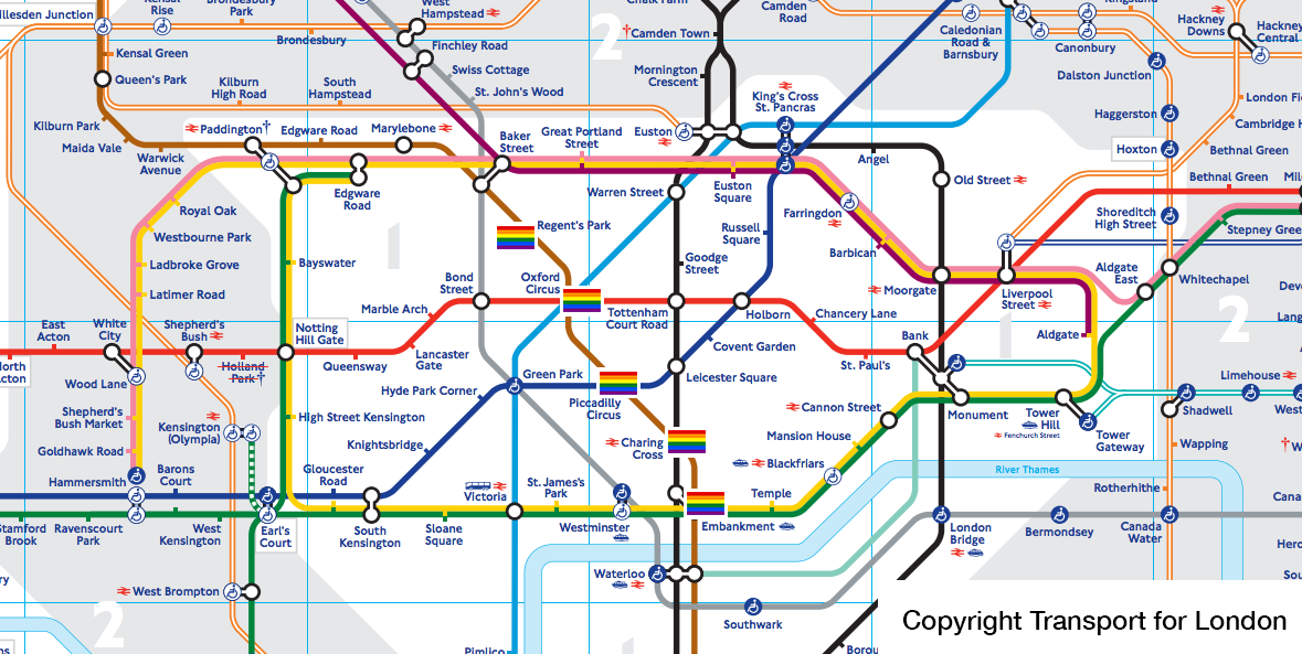
The starting point for the London Pride parade is at Portland Place. The parade makes its way down Regent St, past Piccadilly Circus and then takes a left on to Pall Mall. The parade winds southwards and then stops at Whitehall Place. We’ve marked the closest Tube stations to the route on the Tube Map below.
The Tube
The London Underground will be the best way to get around during London Pride. After all, you won’t have to worry about closed roads if you’re going underground! But there are a few things you should be aware of before you head out the door.
The Tube stations marked on the map above are expected to be busier than normal, however Bond Street, Westminster and St. James’s Park will also be very busy. If you’re going to the parade, you might be better going to Tottenham Court Road or Leicester Square and walking across.
There are planned works for the weekend that shouldn’t directly impact the Pride parade but could potentially cause problems if you’re travelling in.
Circle line: No service on the entire line. (The second weekend this has happened but should be the last).
District line: Trains won’t run between Tower Hill and Barking. There will be replacement buses.
Hammersmith & City line: Trains won’t run between King’s Cross St Pancras and Barking. There will be replacement buses east of Aldgate East.
Metropolitan line: Trains won’t run between King’s Cross and Aldgate.
London Overground: Trains won’t run between Gospel Oak and Barking.
TfL Rail: Before 08:30 trains won’t run between Liverpool Street and Shenfield.
Use Tube Map for live departure times and line status to be aware of any potential delays. Click here or on the image below to learn more.

Buses
Roads around the parade route will either be closed or at least busier than normal. Affected buses will either divert or cut their route short. The affected routes will be: 2, 3, 6, 7, 8, 9, 10, 11, 12, 13, 14, 15, 19, 22, 23, 24, 25, 29, 30, 38, 53, 55, 73, 74, 82, 87, 88, 91, 94, 98, 113, 137, 139, 159, 176, 189, 274, 390, 453 and C2. If you need to keep an eye on things, Bus Times London includes alerts about bus routes and live arrival times. Click here or on the image below to learn more.
Trains
Engineering works at London Bridge will affect some train services. Thameslink and Southeastern trains will not be stopping at London Bridge Station and passengers won’t be able to change onto Southeastern Charing Cross services from there.
Plan your journey ahead of time using myTrains to check for any changes or cancellations.
How to Get Around During NYC Pride
Parade Route
The NYC Pride parade starts at 36th Street and 5th Ave. It then continues southwards down 5th Ave. Then just before Washington Square Park the parade turns on to 8th St and continues towards Christopher and Greenwich streets. The closest subway stations are marked on the map below.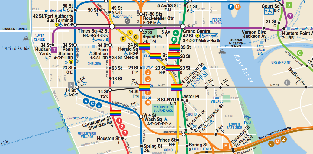
The Subway
The first thing to remember is that the NYC Pride parade is on a Sunday which means services will be operating on Sunday hours. The subway stops marked on the map are likely to be busier than normal due to their proximity to the route. If you’re watching the parade, you might be better off choosing a subway station close to the ones marked on the map and then walking. Most other subway stations in the area are only a short walk. For example 34 St Penn Station is still just a 10 minute walk from the start of the parade route. People hoping to get the subway to/ from Christopher St Sheridan Sq will need to use an alternative route. There will be no service on the 1 line between 14 St and South Ferry. We advise walking to 14 St or W 4 St Wash Sq. To check your line for possible disruptions ahead of time, please check the MTA website for service changes. For live service updates on the day use the Service Status tab in New York Subway on iOS or Android.
Buses
It’s likely that some bus routes will be changed due to road closures along the parade route. There are also a large number of planned changes for Sunday and you can see all of them here. Please Note: The official NYC Pride organisers have written a letter addressing safety concerns in the aftermath of the events in Orlando. To read it in full you can find it here. For more information on NYC Pride you can visit their website or contact them here. We wish everyone a safe and happy Pride. If you would like more information on Pride in London, you can visit their official website here. Update: This weekend, on July 2, Paris and Madrid will both celebrate Pride. In Paris gay clubs, pubs and restaurants will be holding events of their own and thousands are expected to take part in the Pride March. In Madrid there are a whole host of events including music performances, the famous stiletto race and Mr Gay Pride 2016.Image credits:
New York City Heritage of Pride March 2012 by Jere Keys on Flickr
Original Tube Map by Transport for London
Original New York subway map by MTA
Back to blog